Accessing soil maps for your farm in the Goulburn Murray Irrigation District (GMID) or Sunraysia irrigation area just became a bit easier. If you have Google Earth or Google Earth Pro loaded on your computer you can directly download the maps for your area.
How to access the maps
If you do not have Google Earth or Google Earth Pro loaded onto your computer go to the link below and follow the instructions to install Google Earth Pro.
https://www.google.com/earth/desktop/
Once you have Google Earth Pro loaded, click on the relevant link below to download the .kmz files. To open, simply double click on the downloaded .kmz file and they will open in Google Earth Pro.
The download links to the .kmz files can be found for each region below:
Northern Victoria
Mallee
When the map is loaded, click on any part of the soil map and a tab will appear showing the soil type and group at that location (Figure 1 – A).
You can turn on and off the soil layer by clicking the check box next to map name shown in the ‘Places’ pane (Figure 1 – B).
You can also turn on and off individual soil types by clicking the triangle next to the map name, then clicking the check boxes next to each soil type (Figure 1 – C).
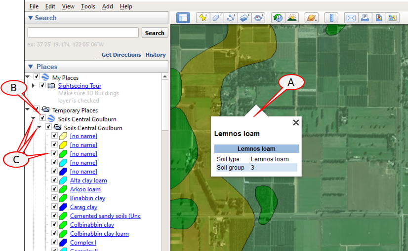
Figure 1: Soil Maps as displayed in Google Earth Pro
Understanding the soil maps
Soils in the GMID have been broadly categorised into 6 groups based on their suitability for irrigation and particular crops.
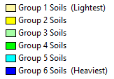
Figure 2: Soil classifications
Group 1 soils are located in the highest parts of the landscape and are generally more undulating and better drained. Groups 1 and 2 are considered most suitable for horticulture crops, Groups 3 and 4 for pasture and shallow-rooting crops, Group 5 for summer fodder crops and annual pastures and Group 6, the lowest in the landscape, is not recommended for irrigation because it is usually prone to intermittent flooding and salinity.
Detailed information
Detailed information about soil chemical and hydraulic properties in the GMID can be found at:
http://vro.agriculture.vic.gov.au/dpi/vro/gbbregn.nsf/pages/soil_hydraulic#database
For more information about the the soils in each region follow the links below.
Central Goulburn
http://vro.agriculture.vic.gov.au/dpi/vro/gbbregn.nsf/pages/soil_survey_goulburn
Murray Valley
http://vro.agriculture.vic.gov.au/dpi/vro/gbbregn.nsf/pages/soil_survey_mvwest
http://vro.agriculture.vic.gov.au/dpi/vro/gbbregn.nsf/pages/soil_survey_mveast
Rochester
http://vro.agriculture.vic.gov.au/dpi/vro/gbbregn.nsf/pages/soil_survey_roch
Torrumbarry
http://vro.agriculture.vic.gov.au/dpi/vro/nthcenregn.nsf/pages/nthcen_soil_dssurveys_torrumburry
Loddon Valley
http://vro.agriculture.vic.gov.au/dpi/vro/nthcenregn.nsf/pages/nthcen_soil_mid_loddon
Swan Hill
http://vro.agriculture.vic.gov.au/dpi/vro/nthcenregn.nsf/pages/nthcen_soil_swhill
All soil maps for North Central Victoria
http://vro.agriculture.vic.gov.au/dpi/vro/nthcenregn.nsf/pages/nc_soil-surveys_map
Red Cliffs
https://vro.agriculture.vic.gov.au/dpi/vro/malregn.nsf/pages/soil_red_cliffs_irirgation
Mildura
https://vro.agriculture.vic.gov.au/dpi/vro/malregn.nsf/pages/soil_mildura_irirgation
Merbein
https://vro.agriculture.vic.gov.au/dpi/vro/malregn.nsf/pages/soil_merbein_irirgation
Nyah, Tresco etc
https://vro.agriculture.vic.gov.au/dpi/vro/nthcenregn.nsf/pages/soil_nyah_tresco_kangaroo_lake
Nangiloc
https://vro.agriculture.vic.gov.au/dpi/vro/malregn.nsf/pages/mallee_soil_nangiloc
Robinvale
https://vro.agriculture.vic.gov.au/dpi/vro/malregn.nsf/pages/soil_robinvale_irrigation
Contacts at Agriculture Victoria
03 5483 1101
Maps and files provided by Agriculture Victoria Research